

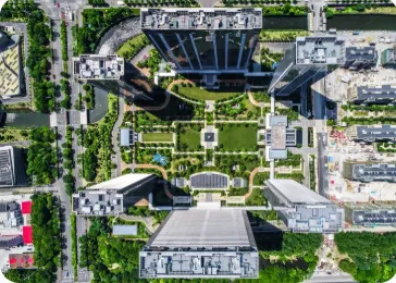
Large-scale community planning shapes how towns grow over time. Every big site plan starts with bold goals for years ahead. City planners want open parks, safe streets, and solid homes for all. Still, showing big land ideas to local people feels hard. Most residents struggle to read complex hill lines or plain zoning maps. They fail to see how streets link to grass parks or how tall structures catch daylight.
This view gap builds real doubt at public hearing talks. Town council reviews stall for months. Project costs climb fast when design change requests pile up week after week. Planners need a direct path to display land goals clearly from day one.
Turning flat land maps into clear visual pictures fixes this problem completely. People grasp the true layout right away. Choices happen much faster. Trust builds between project teams and local neighbors.
Planning Large Communities
Designing a big neighborhood takes real focus across many departments. Planners must balance housing needs, open parks, shops, and bus lines. Years ago, site plans depended on flat paper sheets and ink lines. Staff drew zone borders by hand on big paper sheets. Those drawings marked property lines well, but they failed to show land depth or hill height.
Local citizens could not tell if tall buildings would dwarf small houses nearby. Later on, complex computer tools reached town offices. Early software needed long setup hours and fast computer boxes. Making one full site view took weeks of hard work. Small planning offices faced a tough choice back then. They had to pick flat line maps or slow 3D pictures. Modern software fixes that old community planning struggle.
Modern Urban Challenges
Public doubt causes long delays during land reviews and town meetings. When local citizens view a plain black line drawing, their minds go blank. They worry new streets will bring heavy traffic near local schools. They fear commercial hubs will cut down shade trees and block park views. This fear creates pushback at town hall talks.
So residents demand constant layout changes before voting on land permits. With old visual tools, moving a park or street path took days of work. A designer had to redraw shapes, adjust property edges, and calculate site space again. That slow loop tested human patience. Turning raw land ideas into realistic neighborhood pictures removes this obstacle right away. People see clear layout choices during initial meetings. Talks stay simple. Sustainable projects move forward without long delays.
Visualizing Spatial Layouts
Building green community layouts calls for testing many land choices fast. Using a modern AI masterplan rendering path lets staff turn basic site lines into rich visual neighborhood scenes in minutes. A designer draws simple zone shapes on a tablet screen. Smart software reads those boundaries and adds green parks, solar roofs, paved roads, and walking paths automatically.
You can use an AI masterplan rendering setup to test building heights next to river parks on the spot. If a town board asks for more grass space, you update the site picture right away. Adding AI masterplan rendering into daily planning work saves precious office hours. Planners focus on land flow and public access while software handles background picture tasks. This clear workflow keeps complex projects moving along smoothly.
Transforming Master Workflows
City design offices need tools that manage big site boundaries easily. Bringing AI architecture solutions into land development practices lets teams turn basic site models into realistic community visuals without technical friction. You avoid moving massive files through complex programs. When you utilize AI architecture applications, simple land blocks transform into active neighborhoods with accurate sun rays, trees, and street networks.
That automated step cuts out hours of manual setup work. Modern AI architecture tools give fast visual feedback as staff shift bike paths, home blocks, and drainage ponds. Teams test land choices and green energy options in real time. Work moves forward faster when everyone sees clear site results on screen during project meetings.
Key Planning Efficiency Gains
Adopting modern visual tools cuts out slow routine steps from land planning routines. Design teams spend less time fixing software settings and more time refining green site strategies. Using smart tools like AI architecture speeds up reviews across all project phases.
Key work benefits include:
- Turning flat site maps into clean pictures takes a few minutes.
- Viewing green park layouts and solar angles requires little effort.
- Planning boards approve sustainable land use plans much faster now.
- Drawing large neighborhood views takes far less manual drafting work.
These smart steps help local teams produce top visual plans fast. Small offices manage large land projects without rising office budgets or hiring extra visual staff to render tasks.
Securing Public Support
Clear visual views build solid faith between project developers and residents. When neighbors look at realistic pictures instead of abstract lines, meetings stay calm and productive. Neighborhood groups feel safe because they view exact park sizes and building distances before site work begins. They notice small access points right away.
They can ask for path shifts or tree planting areas early, when changes stay simple and low cost. Changing a digital line takes a few minutes. Moving a paved street on site costs big money and lost time. Clear site pictures build firm trust from the first meeting. Residents stay calm knowing the land plan protects local nature. This visual clarity turns tense public hearings into positive partnerships.
Primary Urban Benefits
New visualization tools bring clear advantages to land planning teams. Creative offices raise total project output without dropping visual quality or spending extra public funds.
Major project benefits include:
- Citizens grasp park scale and street connection layouts easily.
- Planning agencies save large sums on outside visual design services.
- Initial site concepts align smoothly with final built neighborhood spaces.
- Developers test diverse green energy features rapidly across big sites.
Bringing these efficient tools into daily work keeps team stress low. Planning staff produce high-quality proposals that secure fast board approvals every single time without long delays.
Simulating Green Impacts
Real environmental planning calls for showing how natural features interact with built structures over time. Surface texture and tree shade build real ecological value in modern community plans. Advanced AI masterplan rendering engines show how sunlight hits roofs, gardens, and walking paths through changing seasons.
Staff shifts weather and sun settings to display how rain runoff flows through green drainage swales. Adding local trees, grass fields, bike lanes, and bus stops anchors the plan in real life. This extra context lets residents see how a green community protects local wildlife while offering safe housing. Seeing real environmental features in place helps town boards review ecological impacts accurately and make smart land choices for future growth.
Aligning Design Teams
A clear site picture acts as a firm guide for civil engineers, road crews, and landscape builders. When initial land concepts turn into realistic views, potential utility conflicts and road design errors get caught early. Implementing AI architecture workflows ensures that land planners and site contractors share the same spatial goals from day one.
Spotting road grade issues or park drainage conflicts early saves project budgets from costly change orders during field work. Construction leaders like having clear visual views next to complex blueprints. It removes doubt from grading tasks and pipelines. Site work stays on schedule, and the project finishes on budget without public friction.
Future Urban Growth Trends
Land planning software moves forward fast every single year. Future studio work will join real-time graphics with active environmental data inside standard drawing software. Planners will shift zone boundaries, bus stops, and green park ratios live during public town talks. Citizens will walk through digital neighborhoods while clear images update on screens right away.
Utilizing an AI masterplan rendering platform lets teams test traffic flows and energy use in real time. This fluid interaction will change how sustainable communities are planned, reviewed, and built across the world. Design practices that adopt these tools early lead the land planning field. They save time, inspire local groups, and create healthy spaces for years to come.
Conclusion
Visualizing large-scale land use plans with modern digital tools helps planners share sustainable community goals with complete visual clarity. Detailed neighborhood graphics reduce public doubt, eliminate costly project delays, and earn fast council approvals.
Utilizing advanced master planning software at airender.studio empowers urban development teams to elevate overall presentation quality, optimize complex site drafting routines, and bring eco-friendly neighborhood projects to life with total personal confidence every single time.
